
3D Scanning for Geography: Visualising Changing Landscapes
Using Drones to 3D Scan and Print Landscapes
This project bridges the gap between traditional fieldwork and cutting-edge spatial technology, turning physical environments into tactile, 3D-printed and Web VR resources.
The project began during a geography field trip to Oxwich Bay. While students conducted traditional surveys of the sand dunes, I flew the DJI Air 3S around (in Orbit POI mode) to perform a comprehensive 3D scan of the area. Once the footage was captured it ws processed with bothVarjo Teleport and Polycam to turn it into a 3D Gaussian Splat (3DGS) (a highly detailed point cloud that offers a far more realistic representation than standard photography). There was little notable difference between the outputs from Polycam vs Varjo Teleport. (3D Scans can be found at the bottom of this page.)
Following this, a student digital ambassador worked one-to-one to:
Remesh the Data: Using Blender, the student transformed the raw 3DGS point cloud into a solid mesh ready for fabrication.
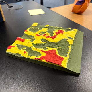
3D Print Topology: We produced a physical model of the dunes, 3D printed in three distinct colours to represent specific topographic elevations.
Geological Scanning: The project expanded to Caswell Bay, where we successfully scanned and 3D printed a carbonate shelf, providing a durable, tactile tool for studying rock formations.


Impact on Teaching and Learning
This project isn't just about creating "cool" models; it's about building bespoke, tactile resources that enhance the curriculum:
Interactive Mapping: The Geography lecturer (Mark Lethbridge) is currently investigating how to embed these interactive 3DGS scans directly into ArcGIS Maps, creating a hybrid digital-physical learning environment.
Pre-Fieldwork Familiarisation: Next year’s students can now explore the topology of Oxwich Bay and Caswell Bay in 3D before they even set foot on the beach, reducing "fieldwork anxiety" and improving data collection accuracy.
Sustainability: By creating virtual "digital twins" , we reduce the need for multiple site visits while maintaining a high level of engagement.
Next Steps:
Student Recruitment: We will soon present these 3DGS scans and physical prints to the current Geography cohort to encourage them to take ownership of the technology and begin scanning their own fieldwork sites.
Iceland Expedition: I will be joining the Geography department on their upcoming trip to Iceland. This environment offers a unique testbed for 3D scanning volcanic features and glacial landscapes, pushing the boundaries of what our student digital ambassadors can achieve.